

Quick answer: To evaluate whether a 55+ community is truly walkable, test the routes you would use most. Look at crossings, traffic speed, sidewalk condition, slopes, shade, seating, lighting, and practical destinations. Then walk the route at the time of day you expect to use it. A neighborhood can look close on a map and still feel inconvenient or uncomfortable on foot.
This checklist helps you compare communities using observable details rather than a single walkability label.
Start With Your Own Definition of Walkable
Walkability is personal. One resident may want a short daily loop. Another may want to reach a park, cafe, library, pharmacy, or community event without driving. Mobility, balance, endurance, weather tolerance, and preferred pace all affect the answer.
Before touring, write down the three walking trips that would matter most to you. Examples include:
- A 10- to 20-minute exercise loop
- A route to a park or green space
- A trip to coffee, lunch, shopping, or an event
- A path to public or shared transportation
- A safe evening walk near home
This prevents a general claim such as “close to downtown” from replacing the more useful question: “Would I comfortably walk the route I expect to use?”
Use a Route-First Walkability Checklist
Evaluate the full trip, not only the destination. A route is only as comfortable as its most difficult segment.
| What to inspect | Questions to ask |
|---|---|
| Sidewalk continuity | Does the sidewalk continue for the full route, or are there gaps that force you onto grass, gravel, parking areas, or the street? |
| Surface condition | Are there cracks, abrupt changes, roots, loose material, drainage problems, or narrow sections? |
| Crossings | Are crossings clearly marked? Is there enough time to cross at a comfortable pace? Can drivers see people waiting? |
| Traffic | How fast and how close does traffic move? Are there driveways or turning lanes that require extra attention? |
| Slope and grade | Does the route include hills that could change how the return trip feels? |
| Shade and weather protection | Is there tree cover or another shaded option during warmer parts of the day? |
| Rest opportunities | Are benches or other appropriate places to pause available along longer routes? |
| Lighting and visibility | Is the route visible after dusk? Are landscaping, parked vehicles, or corners likely to block sightlines? |
| Wayfinding | Is the route easy to follow, and could a visitor describe a clear return path? |
Test the Walk Instead of Relying on Distance
Map distance is a useful starting point, but it cannot show every curb, crossing, grade, construction zone, or traffic pattern. If a destination matters to your routine, walk the route during your visit.
Use a simple three-pass test:
- Outbound trip: Notice effort, crossing comfort, noise, and the clarity of the route.
- Destination stop: Check whether there is a suitable place to sit, enter, wait, or meet someone.
- Return trip: Reassess the route when you are less fresh. A modest slope or long crossing may feel different on the way back.
If possible, repeat the route at another time. Morning traffic, midday heat, evening visibility, and event traffic can create very different conditions.
Check Everyday Destinations, Not Just Recreation
Parks and walking paths matter, but practical destinations often determine whether walking becomes part of daily life. Look for the places you expect to visit regularly:
- Grocery and pharmacy options
- Cafes and restaurants
- Libraries, civic spaces, and community events
- Medical offices and other appointments
- Hair care, banking, shipping, or other errands
- Transit or shared-ride pickup points
Then separate three different ideas:
- Walkable: You would reasonably make the trip on foot.
- Nearby: The destination is close but you may prefer another mode.
- Accessible without driving yourself: A transportation option can complete the trip even when walking is not practical.
This distinction makes community comparisons more realistic.
Evaluate the Community Grounds Too
Off-site access is only one part of the experience. Tour the community grounds using the same practical approach.
Look at the route from the apartment building to the places you would use most, such as mail, parking, outdoor seating, shared amenities, and the public sidewalk. Check whether the path is direct, well lit, and comfortable in changing weather.
Ask where residents typically walk for exercise and how they reach nearby destinations. Specific answers are more helpful than broad descriptions. A leasing team should be able to explain which features are on site and which belong to a neighboring park, city district, or other public space.

Consider Accessibility and Personal Comfort
A route does not need to feel difficult to reveal useful information. Small details can determine whether you use it often.
During your test walk, notice:
- Whether curb ramps align with the crossing
- Whether mobility devices have enough clear width
- Whether signal buttons and entrances are easy to reach
- Whether surfaces become slippery or collect water
- Whether traffic noise affects conversation
- Whether dogs, bicycles, scooters, or crowded events change your comfort
- Whether emergency contact and pickup locations are easy to describe
If you use a cane, walker, wheelchair, or another mobility aid, evaluate the route with that equipment. If you expect to walk with a friend, pet, or visiting family member, test that scenario too.
Ask Better Questions During a Community Tour
Bring a short question list so important details do not get lost during the tour:
- Which nearby destinations do residents commonly reach on foot?
- Can you show me the route rather than only pointing it out on a map?
- Which walking paths and outdoor amenities are on the property?
- Which nearby features belong to a public park or another organization?
- Where are the closest benches, shaded areas, and safe crossings?
- What transportation options are available when weather or mobility makes walking impractical?
- Are any current or planned construction projects likely to change the route?
For a broader comparison, pair these questions with a 55+ community tour checklist covering the apartment, lease, costs, policies, and amenities.
How Park Place Connects to Lawrenceville
Park Place by Highlands is located at 77 E. Pike Street in Lawrenceville. The community has walking paths connecting to Rhodes Jordan Park and Downtown Lawrenceville.
Rhodes Jordan Park is a Gwinnett County park with trails, a fishing lake, sports courts, playgrounds, and an aquatic center. Those are public park features, not on-site Park Place amenities. Downtown Lawrenceville offers restaurants, shops, and community destinations. Conditions and access can change, so prospective residents should test the routes that matter to them during a visit.
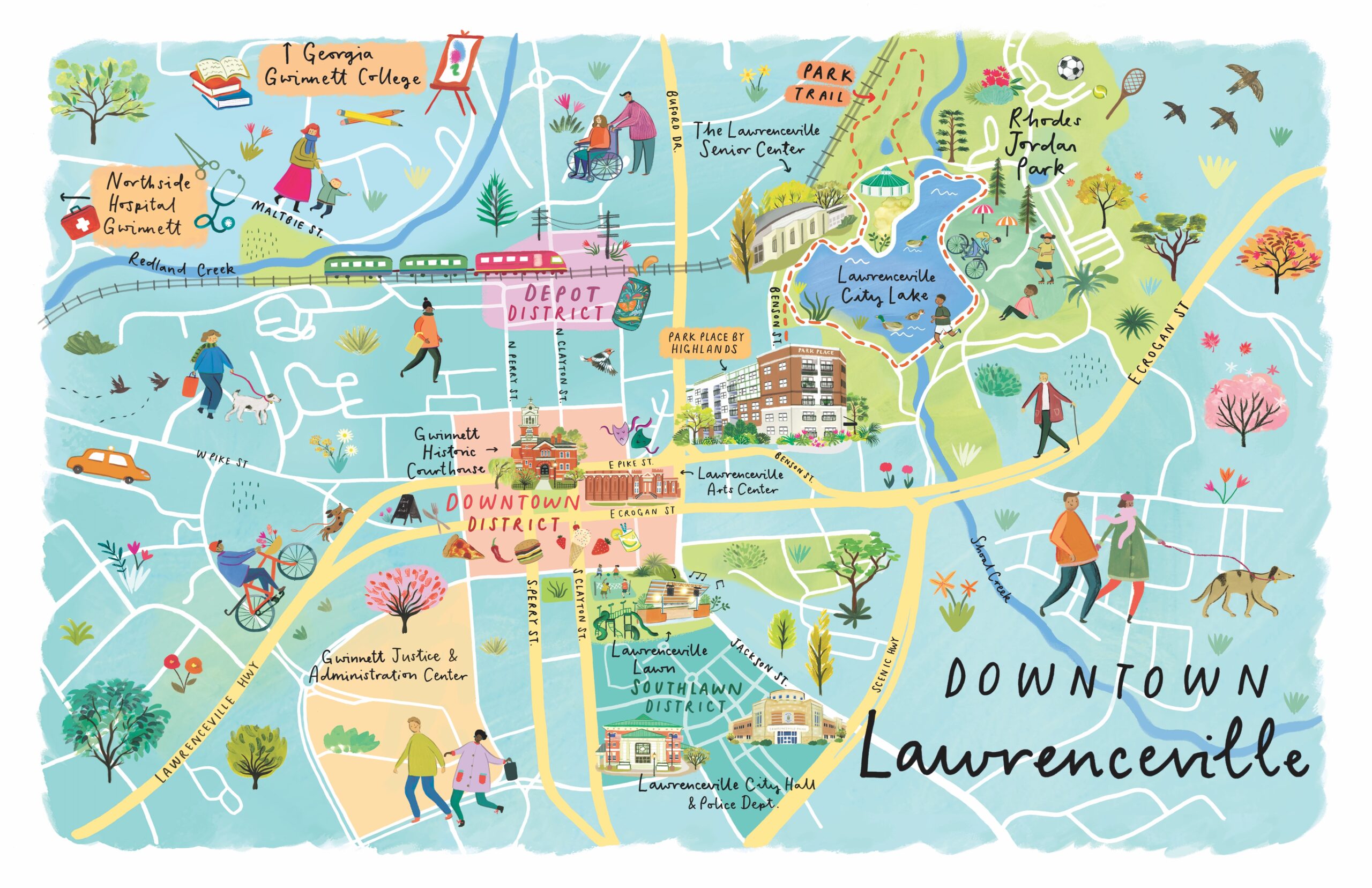
Gwinnett County also provides Microtransit service in designated zones. Service areas, hours, booking rules, and fares can change. Check the county’s current information when planning a trip.
To compare Park Place with other local options, read our guide to 55+ communities in Gwinnett County. For destination ideas, see things to do in Lawrenceville for active adults.
Score Each Route After the Tour
Use a simple score immediately after walking so details remain fresh:
- 5: Comfortable and practical for regular use
- 4: Generally comfortable with one minor concern
- 3: Usable sometimes, depending on weather, traffic, or energy
- 2: Possible but unlikely to become a routine trip
- 1: Not a route you would choose to walk
Score separate routes rather than giving the whole neighborhood one number. A community may offer an excellent exercise loop, a comfortable park connection, and a less practical grocery trip. That is more useful than a single overall score.
The Best Walkability Test Is the One That Matches Your Routine
A walkable 55+ community should support the trips and activities that matter to you. Maps, scores, and mileage can narrow your list, but an in-person route test reveals the details that shape daily comfort.
When you schedule a visit to Park Place by Highlands, bring this checklist and ask to see the walking connections you expect to use. You can also review the community’s on-site amenities and one- and two-bedroom floor plans before your tour.